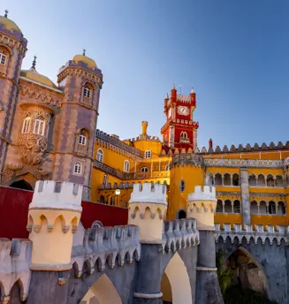
Tickets fot the Palace of Pena
only available for a specific date and time
How to get there
How to get there
Lisbon > Sintra: Train (CP) – Sintra Line
(Departure stations: Oriente; Rossio; Entrecampos)
Sintra (train station) > Monserrate:
Bus n.º 1253 (Carris Metropolitano)
Bus nº 435 (Scotturb)
We emphasize that Parques de Sintra's responsibilities are limited to the parks and monuments under its management. The company is not responsible for any circumstances occurring outside the heritage sites, namely, access and transport to reach said sites.
You can reach the town of Sintra using:
• IC19 (from Lisbon)
• IC30 (from Mafra)
• EN9 (from Cascais, via the A5)
The Park and Palace of Monserrate is located on the road that connects the center of the town centre of Sintra to Colares (EN375).
GPS Coordinates
38°47'30"N 9°25'09"W
We emphasize that Parques de Sintra's responsibilities are limited to the parks and monuments under its management. The company is not responsible for any circumstances occurring outside the heritage sites, namely, access and transport to reach said sites.
How to get there
Lisbon > Sintra: Train (CP) – Sintra Line
(Departure stations: Oriente; Rossio; Entrecampos)
Sintra (train station) > Moorish Castle: Bus n.º 434 (Scotturb)
We emphasize that Parques de Sintra's responsibilities are limited to the parks and monuments under its management. The company is not responsible for any circumstances occurring outside the heritage sites, namely, access and transport to reach said sites.
You can reach the town of Sintra using:
- IC19 (from Lisbon)
- IC30 (from Mafra)
- EN9 (from Cascais, via the A5)
Please note that access to this monument is not authorized to private vehicles. We recommended the use of the pedestrian trails available or public transportation. You can park your car in the historic center of Sintra or the peripheral car parks available.
GPS Coordinates: 38º 47’ 24.25” N 9º 23’ 21.47” W
We emphasize that Parques de Sintra's responsibilities are limited to the parks and monuments under its management. The company is not responsible for any circumstances occurring outside the heritage sites, namely, access and transport to reach said sites.
Marked hiking trails:
SANTA MARIA TRAIL
Starting point: “Info Parques de Sintra”, in S. Pedro de Sintra
Distance: 1.770 metres
Duration: 1 hour
SETEAIS TRAIL
Starting point: Palace of Seteais
Distance: 2.410 metres
Duration: 1h30
VILLA SASSETTI TRAIL
Starting point: Largo Ferreira de Castro
Distance: 1.850 metres
Duration: 45 minutes
How to get there
Lisbon > Sintra: Train (CP) – Sintra Line
(Departure stations: Oriente; Rossio; Entrecampos)
Sintra (train station) > National Palace of Sintra: Buses 434/435 (Scotturb)
We emphasize that Parques de Sintra's responsibilities are limited to the parks and monuments under its management. The company is not responsible for any circumstances occurring outside the heritage sites, namely, access and transport to reach said sites.
You can reach the town of Sintra using:
- IC19 (from Lisbon)
- IC30 (from Mafra)
- EN9 (from Cascais, via the A5)
The National Palace of Sintra is located in the historic centre (at Largo Rainha D. Amélia).
Coordenadas GPS: 38º 47’ 50.50” N 9º 23’ 25.87” W
Please note that the circulation of private vehicles in the historic center is limited to residents. The use of the car parks available and then travelling to the historic center on foot or by public transport is recommended.
We emphasize that Parques de Sintra's responsibilities are limited to the parks and monuments under its management. The company is not responsible for any circumstances occurring outside the heritage sites, namely, access and transport to reach said sites.
Sintra train station – National Palace of Sintra (10-15 minutes)
How to get there
Lisbon > Sintra: Train (CP) – Sintra Line
(Departure stations: Oriente; Rossio; Entrecampos)
Sintra (train station) > Pena: Bus 434 (Scotturb)
We emphasize that Parques de Sintra's responsibilities are limited to the parks and monuments under its management. The company is not responsible for any circumstances occurring outside the heritage sites, namely, access and transport to reach said sites.
You can reach the town of Sintra using:
- IC19 (from Lisbon)
- IC30 (from Mafra)
- EN9 (from Cascais, via the A5)
Please note that access to this monument is not authorized to private vehicles. We recommended the use of the pedestrian trails available or public transportation. You can park your car in the historic center of Sintra or the peripheral car parks available.
GPS Coordinates: 38º 47’ 16.45” N 9º 23’ 15.35” W
We emphasize that Parques de Sintra's responsibilities are limited to the parks and monuments under its management. The company is not responsible for any circumstances occurring outside the heritage sites, namely, access and transport to reach said sites.
Marked hiking trails:
SANTA MARIA TRAIL
Starting point: “Info Parques de Sintra”, in S. Pedro de Sintra
Distance: 1.770 metres
Duration: 1 hour
SETEAIS TRAIL
Starting point: Palace of Seteais
Distance: 2.410 metres
Duration: 1h30
VILLA SASSETTI TRAIL
Starting point: Largo Ferreira de Castro
Distance: 1.850 metres
Duration: 45 minutes
How to get there
Lisbon > Sintra: Train (CP) – Sintra Line
(Departure stations: Oriente; Rossio; Entrecampos)
Sintra (train station) > Convent of the Capuchos:
Bus nº 1253 (Carris Metropolitano) (a 40-minute walking distance to the convent)
Taxi
We emphasize that Parques de Sintra's responsibilities are limited to the parks and monuments under its management. The company is not responsible for any circumstances occurring outside the heritage sites, namely, access and transport to reach said sites.
FROM LISBON/MAFRA
1. Reach Colares using:
> IC19 (from Lisbon) + EN247
> IC30 (from Mafra) + EN247
> EN9 (from Cascais, via the A5) + EN247
2. In Colares: head toward Cabo da Roca up to Pé da Serra.
3. In Pé da Serra, turn left to the EN 247-3, toward the Convent of the Capuchos.
FROM CASCAIS/GUINCHO BEACH
1. Head on the EN 247 toward Colares.
2. After having passed the road to Cabo da Roca, in Pé da Serra turn right to the EN 247-3, toward the Convent of the Capuchos.
GPS Coordinates: 38º 46’ 58.48” N 9º 26’ 8.86” W
We emphasize that Parques de Sintra's responsibilities are limited to the parks and monuments under its management. The company is not responsible for any circumstances occurring outside the heritage sites, namely, access and transport to reach said sites.
How to get there
Lisbon > Sintra: Train (CP) – Sintra Line
(Departure stations: Oriente; Rossio; Entrecampos)
Sintra (train station) > Park of Pena (where the Chalet is located): Bus 434 (Scotturb)
We emphasize that Parques de Sintra's responsibilities are limited to the parks and monuments under its management. The company is not responsible for any circumstances occurring outside the heritage sites, namely, access and transport to reach said sites.
You can reach the town of Sintra using:
- IC19 (from Lisbon)
- IC30 (from Mafra)
- EN9 (from Cascais, via the A5)
Please note that access to this monument is not authorized to private vehicles. We recommended the use of the pedestrian trails available or public transportation. You can park your car in the historic center of Sintra or the peripheral car parks available.
GPS Coordinates: 38º 47’ 9.41” N 9º 23’ 58.48” W
We emphasize that Parques de Sintra's responsibilities are limited to the parks and monuments under its management. The company is not responsible for any circumstances occurring outside the heritage sites, namely, access and transport to reach said sites.
Marked hiking trails to the Park of Pena (where the Chalet is located):
SANTA MARIA TRAIL
Starting point: “Info Parques de Sintra”, in S. Pedro de Sintra
Distance: 1.770 metres
Duration: 1 hour
SETEAIS TRAIL
Starting point: Palace of Seteais
Distance: 2.410 metres
Duration: 1h30
VILLA SASSETTI TRAIL
Starting point: Largo Ferreira de Castro
Distance: 1.850 metres
Duration: 45 minutes
How to get there
Lisbon > Sintra: Train (CP) – Sintra Line
(Departure stations: Oriente Station, Rossio, Entrecampos)
Sintra (train station) > Cabo da Roca:
Bus n.º 1253 (Carris Metropolitano)
CASCAIS (terminal) > PORTELA DE SINTRA (via Azóia and Almoçageme):
Bus nº 1624 (Carris Metropolitano)
We emphasize that Parques de Sintra's responsibilities are limited to the parks and monuments under its management. The company is not responsible for any circumstances occurring outside the heritage sites, namely, access and transport to reach said sites.
If you are departing from Cascais or Colares, you can reach Cabo da Roca using the EN-247 road.
We emphasize that Parques de Sintra's responsibilities are limited to the parks and monuments under its management. The company is not responsible for any circumstances occurring outside the heritage sites, namely, access and transport to reach said sites.
There are several marked pedestrian trails from Cascais, Colares and the Sintra Hills.
How to get there
Lisbon > Queluz
By bus (Carris Metropolitano)
• Bus nº 1717: Lisboa (Colégio Militar, metro station)-Tercena via Amadora Este (metro station). Bus stop - Queluz (4 Caminhos), a 15-minute walking distance to the Palace.
By train (CP) – Sintra Line (Stop at Queluz-Belas station or Monte Abraão station. A 1 km distance to the Palace)
Departure stations:
- Oriente Station
- Rossio Station
- Entrecampos Station
Amadora > Queluz
By bus (Carris Metropolitano)
• Bus nº 1513: Amadora (Hospital) via Queluz. Bus Stop - Queluz (Palace)
• Bus nº 1601: Amadora Este (metro station) via Carcavelos (beach). Bus Stop - Queluz (4 Caminhos), a 15-minute walking distance to the Palace.
Oeiras > Queluz
By bus (Carris Metropolitano)
• Bus nº 1530: Oeiras (North Station). Bus Stop - Queluz (4 Caminhos), a 15-minute walking distance to the Palace.
Carcavelos > Queluz
By bus (Carris Metropolitano)
• Bus nº 1602: Carcavelos (beach). Bus Stop - Queluz (4 Caminhos), a 15-minute walking distance to the Palace.
Sintra > Queluz
By train (CP) – Sintra Line, stop at Queluz-Belas station or Monte Abraão station (a 1 km distance to the Palace)
We emphasize that Parques de Sintra's responsibilities are limited to the parks and monuments under its management. The company is not responsible for any circumstances occurring outside the heritage sites, namely, access and transport to reach said sites.
You can get to Queluz using the following route:
From Lisbon and Sintra
- IC19 (Queluz-Palácio exit)
We emphasize that Parques de Sintra's responsibilities are limited to the parks and monuments under its management. The company is not responsible for any circumstances occurring outside the heritage sites, namely, access and transport to reach said sites.
How to get there
LISBOA > SINTRA: Train (CP) – Sintra Line
(Departure stations: Oriente, Rossio, Entrecampos)
SINTRA (train station) > HISTORIC CENTRE (National Palace of Sintra): Buses n.º 434/435 (Scotturb)
You will then have to cross the Historic Center of Sintra on foot, up to Ferreira de Castro Square, where the entrance to Vila Sassetti is located.
We emphasize that Parques de Sintra's responsibilities are limited to the parks and monuments under its management. The company is not responsible for any circumstances occurring outside the heritage sites, namely, access and transport to reach said sites.
You can reach the town of Sintra using:
IC19 (from Lisbon)
IC30 (from Mafra)
EN9 (from Cascais, via the A5)
The entrance to Villa Sassetti is located nearby the Ferreira de Castro Square, close to the Historic Center.
Please note that the circulation of private vehicles in the historic center is limited to residents and traffic is very restricted. The use of peripheral car parks and travelling to the historic center on foot or by public transport is recomended.
GPS Coordinates: 38°47'44.6"N 9°23'26.4"W
We emphasize that Parques de Sintra's responsibilities are limited to the parks and monuments under its management. The company is not responsible for any circumstances occurring outside the heritage sites, namely, access and transport to reach said sites.
Sintra train station > Villa Sassetti (Ferreira de Castro Square) - 10-15 minutes
How to get there
Lisbon > Belém
By bus: nº 728, 714, 727, 729, 751
By tram: 15
By train: Cascais Line (Belém station)
We emphasize that Parques de Sintra's responsibilities are limited to the parks and monuments under its management. The company is not responsible for any circumstances occurring outside the heritage sites, namely, access and transport to reach said sites.
Head towards Belém. The school facilities are located on Calçada da Ajuda, next to nº 23.
GPS Coordinates: 38º 42’ 00.98” N 9º 12’ 00.08” W
We emphasize that Parques de Sintra's responsibilities are limited to the parks and monuments under its management. The company is not responsible for any circumstances occurring outside the heritage sites, namely, access and transport to reach said sites.
How to get there
Lisbon > Sintra:
Train (CP) – Sintra Line
(Departure stations: Oriente Station, Rossio, Entrecampos)
Sintra (station) > Colares:
Bus nº 1253 (Carris Metropolitano). Bus Stop - Estrada do Cabo da Roca, a 25-minute walking distance to the Sanctuary.
You can reach the Santuary of Peninha from Cascais/Malveira da Serra or Sintra/Colares using EN-247 road.
We emphasize that Parques de Sintra's responsibilities are limited to the parks and monuments under its management. The company is not responsible for any circumstances occurring outside the heritage sites, namely, access and transport to reach said sites.


